

Autumn is in the air, which means it’s time to start planning your fall hiking adventures!
Below, you will find seven hiking adventures with some of the best leaf peeping angles in the region. We picked dog-friendly locations with easy to moderate difficulty so that everyone and their furry friends can get out and enjoy this quintessential Northwest Arkansas activity.
If you are bringing your dog, don’t forget to bring something to pick up after them! Let’s help keep #NWArk beautiful.
Mt. Kessler Loop
Mount Kessler Loop is an 8.2-mile loop trail located at Kessler Mountain Regional Park on the southwestern edge of Fayetteville. For most people, Kessler Mountain will be the quickest to reach out of the seven. And now that it is connected to the Razorback Greenway, you can easily reach the trailhead by bike! An old-growth forest that reaches 1,856 feet above sea level, Kessler is great for hiking and mountain biking with good views available on the backside of the mountain. Be sure to snap a picture of the map at the entry point as the trails are a bit confusing. This trail is rated as moderate.
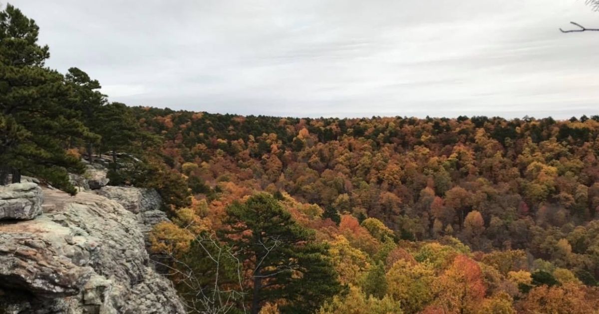
Yellow Rock
Ol’ Yellow Rock! Yellow Rock Trail is a 2.7-mile loop trail located in Devil’s Den State Park near West Fork, Arkansas. The Yellow Rock Overlook sits 300 feet above the valley and offers a panoramic view of the Lee Creek Valley. This trail has several nice rock formations and is rated as moderate. Built in the 1930’s, it has been primarily used for hiking, but we encourage sturdy shoes since it is still quite rocky. Heads up, this one is often busy on the weekends, so plan this adventure during the week if you can.
Sam’s Throne
Sam’s Throne Trail is a moderately trafficked, 2-mile loop trail located near Mount Judea, Arkansas. Sam’s Throne is a well-known rock climbing site with short trails leading down to the bluff edge where you will find breathtaking views of Big Creek valley. Fun fact: the surrounding area contains over 100 named climbing routes of various difficulty.
Pedestal Rocks Loop
Named for its really cool rock formations, the Pedestal Rocks Loop Trail is a 2.2-mile moderately trafficked hike located near Sand Gap, Arkansas. Once you finish viewing the rock formations from atop the bluffs, be sure to hike down below the bluffs to check out several of the walk-through caves. The net elevation change on this one is about 250 feet. If you finish with enough daylight, check out the King’s Bluff Loop Trail located right next to it.
Whitaker Point
Whitaker Point Trail is located near the little town of Deer, Arkansas. Often referred to as Hawksbill Crag, this one is a 2.9-mile lightly trafficked out and back trail that features a waterfall and is rated as moderate. The “Crag”, a rock formation that juts out from the bluff’s face, received its name because it resembles a hawk’s beak. It overlooks Whitaker Creek and a huge valley stretching out into the distance. A bit tougher to reach than the others, we recommend hikers take a 4-wheel drive vehicle up to the trailhead. That said, the drive is sooo worth it!
Kings River Falls Trail
Kings River Falls Trail is a 1.8-mile moderately trafficked out and back trail located near Witter, Arkansas. With beautiful scenery leading the way to the waterfall (and popular swimming hole), this hike is relatively flat and family-friendly. Just upstream from the waterfall, you can hike up to a bluff to get a beautiful view from above. Fun fact: The Kings River is relatively unique for the Ozarks because it flows from south to north.
War Eagle Trail
UPDATE: The lower portion of the War Eagle Trail is closed for repairs due to storm damage. You can still access the overlook from the upper trailhead by parking at the trailhead next to the pavilion on Hwy 23. The overlook is only 1/4 mile from the pavilion, but you can still wind your way down to the creek. In addition, they’ve added a new 1.5-mile loop, which can be accessed from the upper trailhead.
War Eagle Trail at Withrow Springs State Park is near Huntsville, Arkansas and is rated as moderate. The 2-mile out and back trail in the middle of the Ozark hardwood forest is named for the scenic river which runs along its length. You’ll come across a cool little cave with rock formations about halfway down the trail. A little precarious in certain spots (you will want the dogs on a leash!) along the way, a scenic overlook (with views for days) awaits you, located atop a 150-foot-high bluff!
Bonus
If you want to skip the hikes and go straight for some views, see: the overlook at Mt. Sequoyah in Fayetteville, White Rock Mountain near the Mulberry River, the Pig Trail Overlook off of HWY 23, Inspiration Point near Eureka Springs, and the Arkansas Grand Canyon located along HWY 7, near Jasper, Arkansas.